Qantas Connects to New Era of Aircraft E-enablement
Qantas Airways is using high speed satcom and avionics software upgrades to enable a new level of aircraft e-enablement across its commercial flight operations.


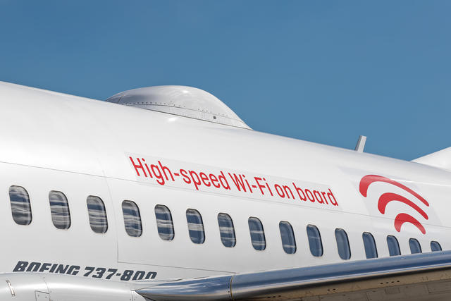
Gate to gate aircraft data transmissions using hybrid satellite connectivity and 3G/4G links is becoming the new reality inside the connected flight decks of Airbus A330s and Boeing 737s in Australia. Here, Avionics International analyzes how Qantas Airways is using satcom and avionics upgrades to transition into a new era of e-enabled flight operations and predictive maintenance.
The journey to enabling Qantas’ new connected cockpit strategy began in 2016 when the airline agreed to a deal with ViaSat to upgrade its B737s and A330s with a hybrid Ku/Ka-band antenna providing access to their first, second and third generation Ka-band and Australian domestic broadband provider NBN’s Ku-band satellite networks throughout the continent of Australia.
While that agreement was geared toward providing in-flight internet to Qantas passengers, it would also help to establish a new medium to replace their use of the aircraft communication, addressing and reporting system (ACARS) datalink for acquiring, transmitting and visualizing aircraft and flight operational data.
Upgrading to ACARS over Satcom
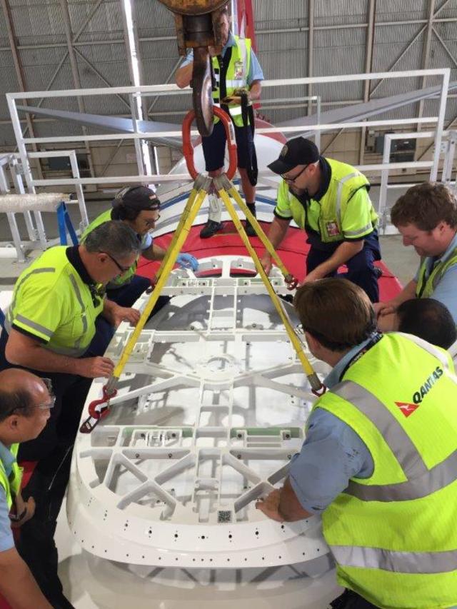
The aircraft upgrade required to enable the use of hybrid satcom involves technicians removing luggage bins and ceiling panels to route new cabling for the aircraft’s antenna, modem server and wireless access points. Most in-service airliners feature four to six access points, including one forward for the pilots.
In June 2018, ViaSat obtained a supplemental type certificate clearing the regulatory requirements for adding its antenna, modem, servers and wireless access points to Qantas’ fleet of A330s. Installations are ongoing and will continue into 2019, according to John Daly, vice president of business operations for ViaSat’s aviation division.
The idea to use ViaSat’s network to replace ACARS was driven by a variety of factors.
Ironically, right around the time that Qantas selected ViaSat and NBN, the airline had recently completed an ACARS over 3G flight trial with Teledyne. Test results from that trial did not provide a business case for making the switch, as it was equal to the performance and cost of paying for the bandwidth to support traditional ACARS messaging.
“After we had completed the ACARS over 3G trials, Qantas was evaluating passenger connectivity options and we ended up selecting ViaSat. That’s when the opportunity came. I went back to Teledyne and said this concept you have over 3G, why don’t we try this with broadband? Eventually, there were teams from Teledyne and ViaSat that discussed ViaSat’s connectivity serving as another medium to the aircraft’s communications management unit (CMU),” Peter Alexander, manager of technical programs, Qantas, told Avionics International.
ACARS has supported air-to-ground aircraft data link messaging since the early 1980s, providing such things as position updates as well as safety service communications between pilots and controllers. As the amount of data and capabilities featured on in-service aircraft has evolved, the low bandwidth and data communications speeds supported by ACARS has required rapid modernization.
That’s why both Sitaonair and Collins Aerospace, the world’s two ACARS data link service providers have both been integrating more internet protocol-based communications media into the traditional aviation specific subscription-based ACARS networks.
Under a 2017 Paris Air Show agreement signed with Teledyne, Qantas deployed software upgrades and new wiring kits to upgrade the multi-application functionality of the existing data acquisition, wireless aircraft interfacing and networking computers. This is enabled by Teledyne’s CMU providing a secure air-to-ground interface via the satcom system. Previously, that air-to-ground interface would have featured ACARS, today it features the speedy satcom channel.
Airlines in recent years have been investing in avionics modifications to enable more robust and speedier data transmissions at lower costs. That was one of the driving factors in the Qantas ACARS over 3G flight trial.
Another factor was that Qantas did not have sufficient geographical coverage in some of the remote areas such as the mining towns they they fly into where they have contracts to transport mining workers to and from larger cities like Sydney. At those locations, instead of sending load sheets, crew departure clearances and notice to aircrew documentation to pilots via ACARS, all of that information was printed manually on paper and physically delivered to and from the aircraft.
“We have flights into mining towns, and one of the issues with some of those remote locations was that on the ground there was no ACARS coverage. That used to force us to change our operations such as manually supplying load sheets, crew departure clearances and printed versions of notice to aircrew documentation which normally we do over ACARS. We’re a big user of ACARS and all of those documents we normally send to the flight deck via ACARS. Now, with NBN and ViaSat the pilots don’t experience any difference in operations if they’re sitting in Sydney or in one of those remote locations, because the connectivity is seamlessly gate to gate,” said Alexander.
Qantas now has the ability to stream up to 250 parameters to the ground in real-time providing an advanced real-time flight tracking and aircraft monitoring solution with many more parameters and at a faster rate than initiatives such as the Global Aeronautical Distress and Safety System (GADSS) are requiring.
Visualizing Weather and Real Time Turbulence in Qantas Connected Cockpits
Qantas A330 and 737 pilots are in the midst of evolving their flight operational data visualization strategy. Software upgrades added to the existing wireless aircraft interface devices on those aircraft brings the airline into a new era of iPad integration into the aircraft’s avionics network.
The aircraft interface device (AID+) that Qantas has upgraded to features a wireless router, ACARS proxy service and ARINC 429/717 aircraft parameter streaming via port based application programmable interfaces. Inside the cockpit the AID+ enables communication between the wireless iPad applications used by pilots and the embedded ARINC 429 data streams. It also links pilot apps to the internet to enable the use of web charts maps and weather.
“We have been using Apple’s iPad as an electronic flight bag ( for the last five years and have become very much embedded within the Apple iOS ecosystem. Being able to add the satellite connectivity to that in combination with the AID+ enables GPS own-ship capability for our pilots using Jeppesen charts. Because the AID+ is connected to the ViaSat system, we get retain general Internet capabilities as well,” said Alexander.
Using iPads in combination with the avionics upgrades will also help Qantas pilots to improve their situational awareness by giving them improved access to long range weather. According to Alexander, prior to introducing the iPad, pilots were mostly limited to the 200 nautical mile visibility of weather that the weather radar on legacy aircraft are capable of.
The goal is to give pilots information about weather further out in front of the aircraft using the iPad and connectivity to visualize the Australian Bureau of Meteorology’s weather forecasting throughout all phases of flight.
Teledyne also included a software developer kit functionality within their AID+ which allows Qantas to develop their own third-party iPad applications that can communicate with the AID+.
“The software upgrade to our AID+ effectively establishes a simulator and development tool available free of charge from our website. This tool makes it very easy for airlines or third-party software developers to build and test new applications on the ground that can interface with GroundLink AID+ airborne AID. Qantas, which has a particularly strong IT function within its operation, and has been using this tool to build and test its own and third-party applications prior to deployment on the aircraft,” said Murray Skelton, director of aircraft solution strategy at Teledyne Controls.
Now, with access to the speed of the NBN/ViaSat network and the ability to introduce their own EFB flight operational applications, Qantas is focused on giving its pilots access to visualized and easy to understand weather updates about their flight route in near real time.
Specifically, is focused on giving pilots access to a more advanced turbulence alerting mechanism on their iPads. The airline is working with DTN, a Minnesota-based provider of actionable visual data insights primarily through web application programmable interfaces linked to safety critical computers across the agriculture, transportation and other industries.
“One of the exciting things we’re working on is in partnership with an organization called DTN that has a deeply advanced turbulence forecasting model, we have an agreement with them in place, where we’re looking to provide real time turbulence alerting inside the flight deck using ViaSat connectivity,” said Alexander.
Navigating around clear air turbulence is one of the crucial uses of connectivity sought by flight operations departments at commercial airlines globally. Delta pilots, for example, use cabin-based Gogo Wi-Fi as connectivity for an EFB app that uses algorithms developed by the National Center for Atmospheric Research.
The app allows Delta’s pilots to set threat index alerts generated from aircraft sensor data. The app’s algorithms use a combination of vertical accelerometer and atmospheric state data, including aircraft-specific behavioral data such as pitch, roll and wind speed to formulate app-based turbulence reports for pilots in real time.
At Qantas, Alexander wants pilots to be able to visualize where turbulence is located using DTN’s advanced forecasting model. DTN’s Flight Route Alerting engine requires Qantas pilots to provide their flight plans up to 36 hours in advance, and the service then generates weather-related impact alerts from our four-dimensional geospatial database throughout the duration of the flight.
Flight Route Alerting features 14 different weather parameters that users can choose from and a core flight hazard dataset within the alerting engine. These features have been enabled through DTN’s investments in developing a suite of mission-critical intelligence around weather-related flight hazards.
They have focused on improving their forecasting models for aviation with a focus on including flight-level specific turbulence, icing, and thunderstorm forecasts, according to Wesley Hyduke, aviation product manager, DTN.
To accompany the text-based alerts generated from DTN’s Flight Route Alerting engine, Qantas is also consuming DTN’s catalog of discrete geospatial weather data so that pilots will be able to graphically view the weather content that generated the alert, Hyduke said.
Starting in the first quarter of 2019, Qantas will begin beta testing DTN’s new NowCast rapid updating short term forecasting application designed to allow aircraft dispatchers and pilots to decide on minimum-cost tactical reroutes during flight if forecast conditions change significantly.
“By providing real time turbulence forecasting for our pilots, it brings more safety and comfort to our passengers as we can optimize flight paths through and around turbulence using a graphical display of what’s happening. Turbulence reporting currently on most commercial aircraft is limited to ACARS text-based data and sometimes that’s hard to visualize with a 4D polygon how its going to impact the aircraft. By having a graphical alert through a connected EFB, it makes it much easier to understand exactly where the turbulence is,” said Alexander.