Electronic Flight Bag Applications Advance, Including Those with NASA’s TASAR


Advancements in electronic flight bag (EFB) applications are providing pilots and aircraft operators a number of benefits, including the ability to get weather updates to decide how and whether to proceed with a flight, seek re-routes, save fuel and fly more efficiently.
A decade after the introduction of the iPad, pilots are using EFBs to eliminate the onboard portage of heavy flight bags with thousands of pieces of paper for each flight, and EFB apps are allowing pilots to lessen planning time previously spent studying charts and figuring how conditions would affect flights.
Pete Grau, the lead principal engineer for the SAE ITC ARINC Industry Activities Program, who runs SAE’s EFB Users Forum, said that COVID-19 led to the cancellation of the spring 2020 forum, as airlines have instituted bans on unnecessary travel, are working reduced hours and face significant layoffs. The EFB Users Forums are spring and fall gatherings of airline avionics engineers, EFB program managers, EFB app and mount-makers, and airplane and systems designers to formulate industry consensus on the safe and secure use of EFBs in a way that regulators can manage.
Despite the cancellation of this spring’s forum, Grau said that “new and more sophisticated EFB applications continue to be developed.”
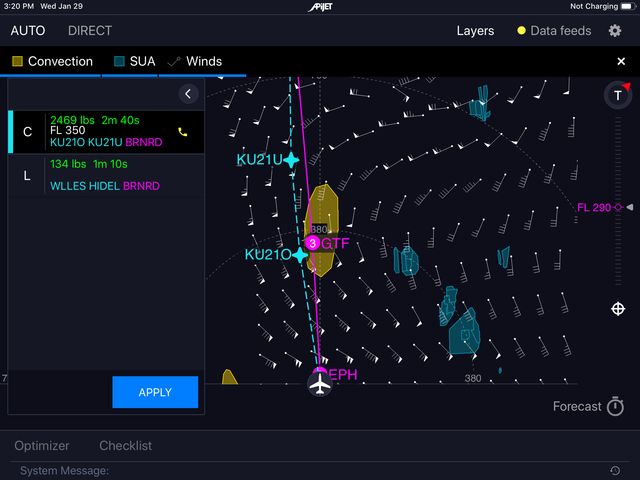
“Satellite weather is commonly accessible, and TASAR (Traffic Aware Strategic Aircrew Requests) has been successfully tested and is now available,” he wrote in an email to Avionics International. “Developed by NASA, TASAR leverages cockpit automation and connectivity for optimized airborne rerouting. Current weather, winds, airspace restrictions, and other traffic are all considered, while horizontal, vertical, and combination solutions can be selected. Pilots can also choose from different objectives such as minimizing fuel burn, trip time, or cost for operational savings. TASAR is also adaptable to different aircraft types and can be installed on various EFB architectures.”
Seattle-based APiJET’s TASAR-based EFB app, Digital Winglets™, for example, aims to provide fuel and flight time savings. The app incorporates avionics data from onboard navigation equipment, data sharing from airborne and ground sources, communications leveraging IP links with the aircraft, and Automatic Dependent Surveillance-Broadcast (ADS-B) IN surveillance data to de-conflict route recommendations for nearby traffic. TJ Horsager, the vice president of business development and sales for APiJET, said that the surveillance data increases Air Traffic Control acceptance rates “translating into more fuel and flight time savings for airlines.”
For a number of EFB app suppliers, aircraft interface devices (AIDs) are key, as they facilitate access to multiple aircraft data and communications channels. With the increased use of EFB apps and the elimination of paper charts and binders, AIDs have become the foundation of most Aircraft Data Management (ADM) systems. Using tablets and computer screens in aircraft, pilots are able to receive all the benefits of EFBs via their AIDs for improved decision-making to bolster situational awareness and safety, minimize errors, monitor aircraft parameters and reduce the workload of the crew.
Horshager said that all of APiJet’s products leverage some type of real-time aircraft data access through an AID or operational server.
“We’re huge advocates of this type of equipment and the value which can be unlocked by real-time aircraft data when combined with intelligent applications such as our Digital Winglets™, Turnaround, AHM and Flight Tracking applications,” he said. “APiJET software is built upon an AID/server agnostic, data platform which we call the APiJET Smart Aircraft System™.”
In April last year, Alaska Airlines announced a partnership with APiJET to install TASAR technology on its entire fleet, and Horshager said that, while many airline projects remain on hold due to COVID-19, APiJET wants to advance its TASAR technology with Alaska Airlines.
Appareo Aviation’s Stratus Insight EFB app connects to Avidyne Avionics’ IFD440, 540, and 550 navigators and “allows pilots to push and pull flight plans from Stratus Insight into the navigator,” said Kris Garberg, president of Appareo Aviation.
While Stratus Insight does not connect to satellite communications devices yet, the app does connect to many ADS-B receivers other than Stratus receivers, to send TIS-B [Traffic Information Service-Broadcast], FIS-B [Flight Information System-Broadcast], GPS and attitude information to the app. If an aircraft has in-flight WiFi, users would be able to connect to the Internet and utilize Stratus Insight's enhanced weather products, and users would also be able to submit pilot reports of turbulence (PIREPs) over that connection, according to Garberg.
Like other EFB app creators, Boeing’s ForeFlight LLC has taken advantage of the benefits of AIDs to increase functionality.
“When connected to an aircraft interface device that provides inflight Wi-Fi, ForeFlight can stream high-definition weather, both real-time radar and many kinds of forecast data, as well as all other data that is normally only available with an Internet connection on the ground,” said Stephen Newman, executive vice president of sales and marketing at ForeFlight, LLC.
In terms of enhanced capabilities for pilots, Newman said that the ForeFlight Mobile app “offers integrations with a myriad of installed avionics and portable aviation receivers.”
“These integrations can enable pilots to obtain inflight traffic and weather, view aircraft position and attitude information, share flight plans to and from their installed avionics, and much more,” he said. “Together with industry-leading Jeppesen navigation and flight data, ForeFlight’s capabilities drastically increase a pilot’s situational awareness and put critical information at the pilot’s fingertips.”

When connected to most Satcom Direct or Gogo inflight Wi-Fi networks with ForeFlight's Performance Plus or Business Performance subscription plans, the app is also able to receive GPS position, pressure altitude, and attitude and heading reference system (AHRS) derived attitude information from software-defined radio (SDR) and Gogo devices. ForeFlight also provides an option when connected to these devices to disable streaming Internet data to ForeFlight, a disabling which ForeFlight said helps lower bandwidth costs.
Over the past year, ForeFlight has been releasing upgrades for its ForeFlight Mobile app each month to add value for corporate flight departments and pilots.
“One of the most significant threads has been the continual development of ForeFlight's ‘3D View’ capabilities, starting from an interactive airport familiarization tool and greatly expanding in scope to include post-flight debriefing and pre-flight previews of the planned route and approach, all in a three-dimensional environment with high-resolution terrain and aerial imagery,” Newman said.
“Even more significant for flight departments is our new collaborative flight planning tool: ForeFlight Dispatch,” he said. “This online capability is fully integrated with the ForeFlight Mobile app, allowing flight planners and ops centers to release planned and filed flights directly to crew members, along with a detailed briefing package, waypoint-by-waypoint navlog for inflight use, and any other documents needed for the flight.”
For its part, Garmin said that it has been leveraging its acquisition of Flight Plan LLC (FltPlan) in 2018 to enhance the capabilities of the Garmin Pilot app by allowing the app to integrate with the FltPlan.com website. Pilots in the U.S. are able to access Pre-Departure Clearances (PDC) at select airports within the app, and for international flights, pilots are able to access Electronic Advance Passenger Information System (eAPIS) services within the app to upload passenger and crew manifest information for U.S. Customs and Border Protection.
“We’ve made additional enhancements to the Garmin Pilot app on a global scale,” Garmin wrote in an email to Avionics International. “This data includes airport traffic patterns, TMZ/RMZ [transponder mandatory zone/radio mandatory zone] airspaces, airport entry routing lines and more. These additions better support operations for pilots flying VFR [visual flight rules] in Europe.”
As far as an AID, Garmin said that Connext is able to link Garmin Pilot with select Garmin avionics systems to display Automatic Dependent Surveillance-Broadcast (ADS-B) weather and traffic, Sirius XM Weather, and audio control, and to support bi-directional transfer of flight plans, texts, and voice calls.
Satellite connectivity can further enhance Garmin Pilot. When the app is connected with a Garmin GSR 56 satellite datalink, the app displays weather received by the GSR 56 “so pilots can easily view and access weather data in-flight in the app,” according to Garmin. In addition, the GSR 56-connected app allows passengers and crew to communicate by text and voice and track the position of the aircraft.
Among the newest features of Garmin Pilot are navigation capabilities that meld with the Instrument Flight Rules features of Garmin flight decks and avionics systems for areas such as loading and activating instrument approach procedures and departures.
With the Garmin FlightStream 510 multi-media card (MMC), pilots are able to use Database Concierge, the wireless transfer of aviation database information from Garmin Pilot to the avionics systems.
“Flight Stream 510 also supports the wireless transfer of flight plans to/from the app and the avionics, as well as the sharing of traffic, weather and GPS position information with Garmin Pilot,” according to Garmin. “These connectivity features reduce pilot workload and streamline the database update process in the cockpit.”
In addition to the flight efficiency, cost, and pilot workload benefits of EFB apps, some may also provide safety benefits.
The Xavion app by entrepreneur Austin Meyer provides an iPad-powered backup of primary flight instruments to allow pilots to reference if the instrument displays go black.

According to Meyer, when connected to an external GPS unit, the Xavion instrument readings “can rival the ones built into your panel.” If an aircraft experiences engine failure, Xavion is able to plot a guide to the nearest, safest runway. In addition, Xavion is able to estimate fuel burn at different altitudes so that a pilot can choose the most efficient flight path, and, according to Meyer, the app provides “synthetic vision without the cost of a traditional glass cockpit” by revealing a clear picture of surrounding terrain.